Topography of Beckley Furnace area

Topographical Map

We extracted this from an 1896 United States Geological Survey topographical map of the area.  We selected this particular edition of the map because the railroad was there (although not all of it — particularly the sidings) is reflected here.  There are clues on this map about why this site was selected for building Beckley and the other furnaces.  As well, 1896 was a time when three furnaces were active in the immediate area.

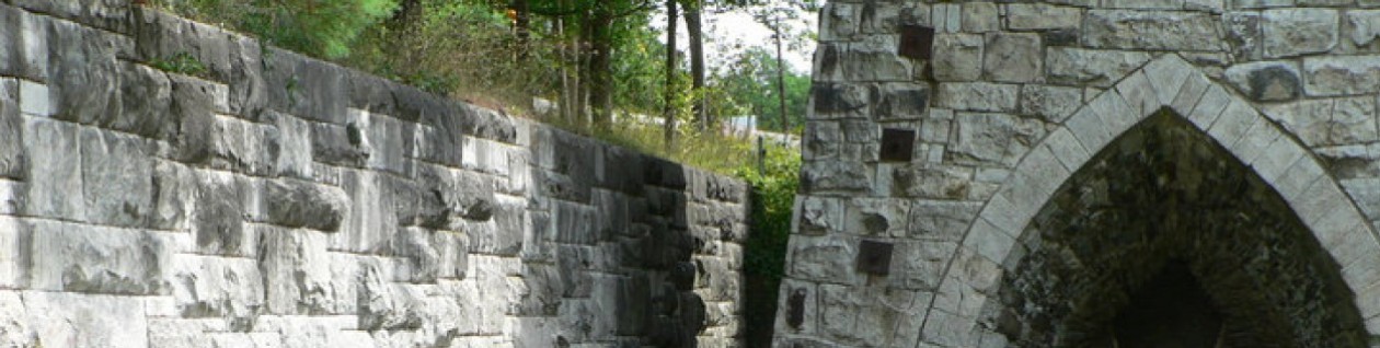
The Beckley Furnace complex is located on the Blackberry river, in the lower right hand section of the map, slightly to the west of East Canaan.

1896_topography

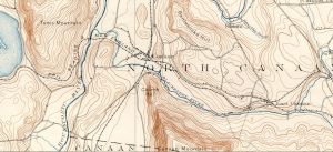
The iron ore that was used at Beckley Furnace came from an area about five miles west of the left edge of this map.  The limestone came from quarries within a mile of the furnaces.  The charcoal initially came from the mountain directly south of the furnaces, but ultimately it came by rail from as far away as Vermont.

Something to think about:  Why do you suppose Beckley and the other East Canaan furnaces were built where they were?  Why not on the mountain to the south?   Do the contour lines in the topographic map (see the close-up below) give you any clues?  

Notable on the map is the limited number of black dots indicating a structure.  One would expect that there would be more structures shown in an area that contained three working blast furnaces as well as ancillary structures, like charcoal sheds and houses for workers and their families.

Here’s a close-up from the map

topo_tighter

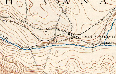
In this view you can clearly see the Beckley complex, the site of East Canaan #1 (the Forbes furnace), but, oddly, Furnace #3, known as the “Furnace in the Field” is not shown on the map, although we know that it was in operation at that time.  We ascribe this to an error by those preparing the map.


Missing Pieces

The Missing Pieces…

Ever wonder if there was anything at the furnace when it was running and is not there today? Well there definitely are some “missing pieces”.  Several of them were essential to making iron.  Just what were these Missing Pieces?

Essential missing pieces:

1. There used to be a bridge running from the top of the furnace to the brick wall across it. That’s how they would get iron ore, charcoal, and limestone to the furnace.

2. There used to be a building behind the furnace where air was heated before being forced into the furnace.  Sometimes it’s called the stove.

3.  There used to be a big pipe that ran down the back of the furnace and into the stove.  This pipe captured hot gasses, largely carbon monoxide, at the top of the stack and recycled them into the hot air mix.

4.  There used to be “blowing tubs” up near where the turbine is housed now.  These devices, really two large wooden barrels about 6 feet in diameter, were powered by the turbine and compressed air, forcing it down to the stove to be heated and forced into the furnace.  The blowing tubs were the air compressor of those times.

5. There used to be a pipe or other kind of air container that ran from the blowing tubs to the stove.  It carried the compressed air to be heated and forced into the furnace.

6.  The furnace itself used to be in a building called the “casting shed”.  This building, with a sand floor, was where the slag and molten iron ran out of the hearth (when it was tapped, of course) into molds in the floor of the furnace where the molten iron cooled and hardened into “pigs” of cast iron.

Outside the basic set-up (but still important):

1. Above the charging wall was a network of sheds for storage of charcoal, limestone, and iron ore to be added to the furnace when needed.

2. Also above the charging wall were railroad tracks that connected to the Central New England Railroad, which ran through East Canaan.  Rail was the most efficient way to bring in charcoal (from as far away as Vermont), iron ore (from Salisbury and Lakeville), and whatever else was needed for the operation of the furnace.  (We think that the limestone came mostly from the quarry further down Lower Road).

3. A company store would have been an important feature of an iron refining community as large as East Canaan was, with three working blast furnaces.

4. Housing for workers.  You can see some remaining Barnum & Richardson worker houses on the north side of Lower Road a short distance further along it.  They are private residences today.

5. HUGE slag piles (we’re told that massive slag piles covered most of the south bank of the Blackberry River — the slag pile that remains is substantial, but small compared with what once was there.

Other things:

1.  We know that there was a sawmill on site, located between the blowing tubs and the stove, where the Loeffel Turbine currently sits.  That’s what the Loeffel turbine was for: to power the sawmill.  Why a sawmill?  Well, that’s addressed in greater detail in the Loeffel turbine post, but one possibility is to saw the various exotic woods used in the iron business, such as the lignum vitae bearing on the turbine and the molds used for casting railroad car wheels.  This is an incomplete chapter in our research of Beckley Furnace.

Have you spotted anything else missing?  Let us know about it!!