How did the iron ore get into the furnace?

How the did the iron ore get into the furnace?

That’s an interesting question!

The simple answer is that iron ore, charcoal, and limestone were dumped into the top of the furnace, but there’s more to it than that.

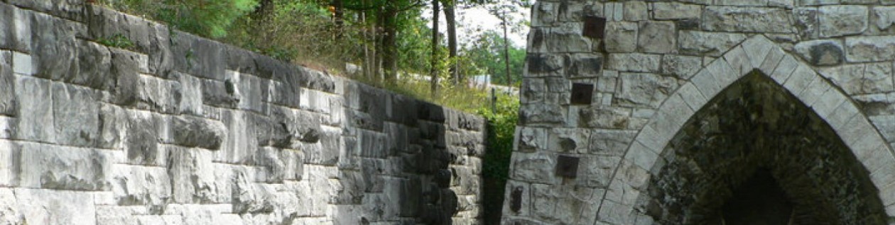
The way it got to the top of the furnace was via a bridge that ran from the top of the furnace across Lower Road to the top of the “charging wall”

Charging wall at Beckley

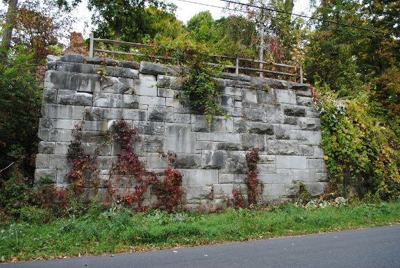
The charging wall the high stone wall you see on the north side of the road, across from the furnace. Workers pushed wheelbarrows of iron ore, of charcoal, and of limestone across that bridge to the furnace.

charcoal cart
Charcoal cart, used to dump charcoal into the top of the furnace

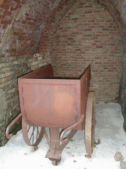
(Here’s a photo of a charcoal cart — it could hold a lot of charcoal.  The carts for limestone and iron ore were smaller because limestone and iron ore are heavier.)

Beckley_Furnace_old
Photo of the bridge between the charging wall and the top of the furnace

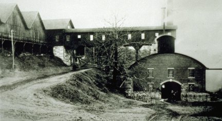
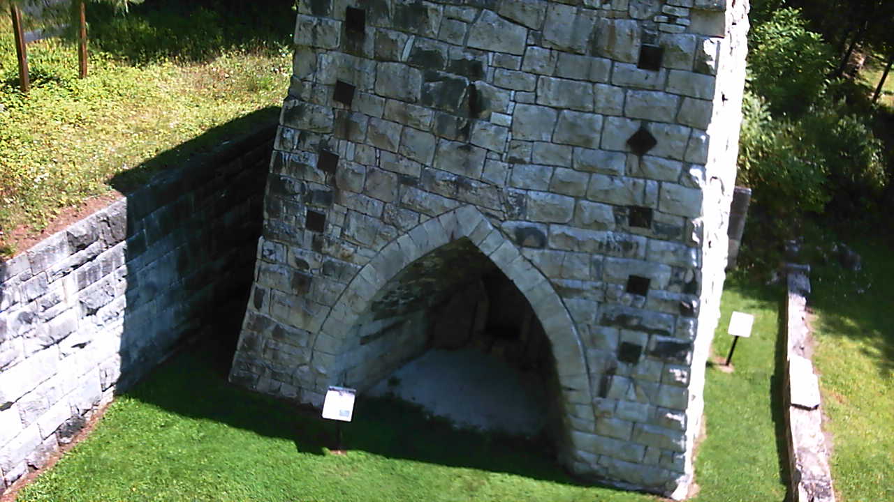
You can see the bridge in this photo — it’s one of the missing links in the reconstructed furnace.  It was enclosed (to keep the charcoal, iron ore, and limestone dry, not to mention the walkway where the men wheeled the wheelbarrows) and you can see it running from the charcoal sheds in the upper left to the top of the furnace on the right.

Before they could dump it in, the blast had to be stopped briefly — and when that was done, the workers had to hustle to get the wheelbarrows dumped before the blast restarted. If the blast was stopped for too long, the liquid iron and slag already in the furnace would solidify. If the blast wasn’t stopped long enough, the workers with the wheelbarrows could have been asphyxiated by the carbon monoxide from the furnace forced into the room where they were dumping their wheelbarrows.

Something to think about:  Today we  have machines that handle feeding blast furnaces, usually operating under computer control.   Yet at Beckley Furnace people did that job using wheelbarrows.  What might have caused the change in methods over the years?  What have been some of the effects of this kind of change?

What and Where was the Casting Shed?

Where (and what) was the casting shed?

(this post came from the old website, with a few modifications) barnum_and_richardson_small 
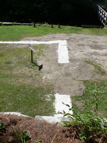
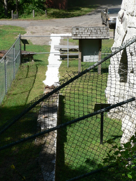
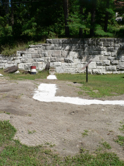
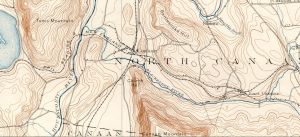
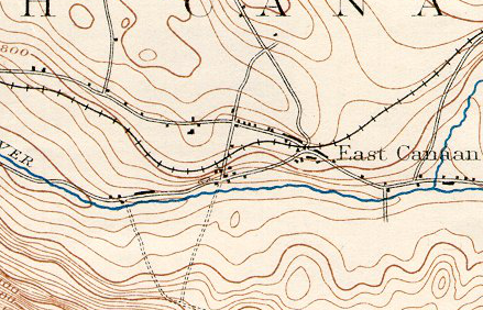
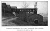
A question we’re frequently asked (not as frequently as we’re asked “What was this place, anyway?” but still pretty frequently) concerns the place of the blast furnace in the overall scheme of things at Beckley. After all, there’s this magnificent stone column standing there, and somehow it looks more like a work of Neolithic sculpture than an industrial artifact. So, we don’t blame people for being a little disoriented and confused! One of our most important tasks as Friends of Beckley Furnace is to “interpret” what you see there — to make it comprehensible. Toward that end, since the stone column at Beckley Furnace was the furnace itself, and the furnace was only a part of a much larger industrial facility, we’ve started making it easier to understand that the furnace was actually located in a long-vanished building called the casting shed. As well as containing the furnace itself, the casting shed also was the place where the molten iron was drawn from the furnace into impressions in a bed of casting sand, making the familiar sow-and-piglet pattern, which gave rise to the term “pig iron”. To start with, here’s a photograph of Beckley Furnace in operation around 1896 (before the fire of 1896): Beckley_Furnace_old 
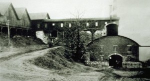
(the source of the image is “Scrap Book of North Canaan”)

In the lower right corner of the picture, you will see the casting shed, the building with the curved roof. Running horizontally across the middle of the picture is the passageway used to transport the charcoal, iron ore, and limestone from the top of the charging wall (at extreme left, to the left of Lower Road) to the top of the furnace.

Now, how to relate that to what you see at Beckley Furnace today: You’ll see that we have outlined the foundation of the casting shed you see in the picture above with limestone.

Casting shed outline 001_web_front

The gap in the outline is where the casting shed door you see in the picture above was located.   (This photo is looking down on the casting shed’s western wall. The furnace is off screen to your left. The white limestone shows where the walls of the casting shed once stood.)

Casting shed outline 006web_front

In this photo, we’ve backed up a bit from the one above.  (Note that the chain link fence that protected the furnace stack during restoration is no longer present today).

Casting shed outline 014_web_front

This photo is looking  westward, from the ruins of the boiler house. The furnace appears on your right in the photo, and Blackberry River is off screen to your left (once again, that chain link fence isn’t there anymore).

Casting shed outline 015_web_front

Looking northward, toward the remains of the north wall of the casting house (and where we took the first photo in this set)

So, that outlines where the casting shed was!!

Why do you suppose they put the furnace in a building to begin with?  Well, one important reason was to protect the molten iron from rain or snow.  Have you ever seen what happens when a few drops of water land in a very hot frying pan?  Now, remember that the molten iron was far hotter than the hottest frying pan….what might have happened?

The Fire of 1896 at Beckley Furnace

The Fire of 1896

The fire of 1896 put Beckley Furnace out of commission for three full years.   Interestingly, this may also have been when the decision was made to raise the height of the furnace to 40 feet. We do know that Barnum and Richardson encountered many difficulties  in getting the furnace back in commission.

Friend of Beckley Furnace Richard Paddock has studied the Fire of 1896 in considerable depth.  In addition to more readily available sources, he searched the local newspapers of the time for events occurring  during the period the furnace was out of commission.  You can read his complete report by clicking on The Fire of 1896

Thanks to Dick for this study!  We will be following it with additional studies that are intended for those who are interested in Beckley Furnace, the Barnum and Richardson Company, and the iron industry in the Upper Housatonic Valley at a level that goes beyond the casual.

A Different Angle…

Looking at things from a different angle…

We’re always looking for better ways to help visitors understand how Beckley Furnace worked.  Fact is that few of our visitors are intimately familiar with the process of making iron ore into pig iron, and putting all the pieces together can be a little problematical.  And, unfortunately, some pieces of the puzzle of just how the entire furnace worked are missing.  Sometimes, we’ve found, looking at things from a different angle can help with this.

PICT0079

As it turns out, Dick Paddock and Christian Allyn, two members of the Friends of Beckley Furnace, have recently been experimenting with our version of a drone — actually, a little remote controlled helicopter that can carry a camera — as a way to explain things better.

The photo above is one of their early efforts — this one, about 60 feet in the air, looking down at the casting arch.  You can see a portion of the exterior wall of the building in which the furnace was located on the left and right of the stack (and see the remainder of the outline of the casting house outlined in limestone elsewhere on this site.)

We think that viewing things from above suggests a lot of possibilities, such as showing the spatial relationship between the  turbine location and the furnace — and even the slag heap — in a single photo.  Stay tuned!  We’ll have more!!

And thanks to Dick and Chris for making this happen!

Topography of Beckley Furnace area

Topographical Map

We extracted this from an 1896 United States Geological Survey topographical map of the area.  We selected this particular edition of the map because the railroad was there (although not all of it — particularly the sidings) is reflected here.  There are clues on this map about why this site was selected for building Beckley and the other furnaces.  As well, 1896 was a time when three furnaces were active in the immediate area.

The Beckley Furnace complex is located on the Blackberry river, in the lower right hand section of the map, slightly to the west of East Canaan.

1896_topography

The iron ore that was used at Beckley Furnace came from an area about five miles west of the left edge of this map.  The limestone came from quarries within a mile of the furnaces.  The charcoal initially came from the mountain directly south of the furnaces, but ultimately it came by rail from as far away as Vermont.

Something to think about:  Why do you suppose Beckley and the other East Canaan furnaces were built where they were?  Why not on the mountain to the south?   Do the contour lines in the topographic map (see the close-up below) give you any clues?  

Notable on the map is the limited number of black dots indicating a structure.  One would expect that there would be more structures shown in an area that contained three working blast furnaces as well as ancillary structures, like charcoal sheds and houses for workers and their families.

Here’s a close-up from the map

topo_tighter

In this view you can clearly see the Beckley complex, the site of East Canaan #1 (the Forbes furnace), but, oddly, Furnace #3, known as the “Furnace in the Field” is not shown on the map, although we know that it was in operation at that time.  We ascribe this to an error by those preparing the map.


Missing Pieces

The Missing Pieces…

Ever wonder if there was anything at the furnace when it was running and is not there today? Well there definitely are some “missing pieces”.  Several of them were essential to making iron.  Just what were these Missing Pieces?

Essential missing pieces:

1. There used to be a bridge running from the top of the furnace to the brick wall across it. That’s how they would get iron ore, charcoal, and limestone to the furnace.

2. There used to be a building behind the furnace where air was heated before being forced into the furnace.  Sometimes it’s called the stove.

3.  There used to be a big pipe that ran down the back of the furnace and into the stove.  This pipe captured hot gasses, largely carbon monoxide, at the top of the stack and recycled them into the hot air mix.

4.  There used to be “blowing tubs” up near where the turbine is housed now.  These devices, really two large wooden barrels about 6 feet in diameter, were powered by the turbine and compressed air, forcing it down to the stove to be heated and forced into the furnace.  The blowing tubs were the air compressor of those times.

5. There used to be a pipe or other kind of air container that ran from the blowing tubs to the stove.  It carried the compressed air to be heated and forced into the furnace.

6.  The furnace itself used to be in a building called the “casting shed”.  This building, with a sand floor, was where the slag and molten iron ran out of the hearth (when it was tapped, of course) into molds in the floor of the furnace where the molten iron cooled and hardened into “pigs” of cast iron.

Outside the basic set-up (but still important):

1. Above the charging wall was a network of sheds for storage of charcoal, limestone, and iron ore to be added to the furnace when needed.

2. Also above the charging wall were railroad tracks that connected to the Central New England Railroad, which ran through East Canaan.  Rail was the most efficient way to bring in charcoal (from as far away as Vermont), iron ore (from Salisbury and Lakeville), and whatever else was needed for the operation of the furnace.  (We think that the limestone came mostly from the quarry further down Lower Road).

3. A company store would have been an important feature of an iron refining community as large as East Canaan was, with three working blast furnaces.

4. Housing for workers.  You can see some remaining Barnum & Richardson worker houses on the north side of Lower Road a short distance further along it.  They are private residences today.

5. HUGE slag piles (we’re told that massive slag piles covered most of the south bank of the Blackberry River — the slag pile that remains is substantial, but small compared with what once was there.

Other things:

1.  We know that there was a sawmill on site, located between the blowing tubs and the stove, where the Loeffel Turbine currently sits.  That’s what the Loeffel turbine was for: to power the sawmill.  Why a sawmill?  Well, that’s addressed in greater detail in the Loeffel turbine post, but one possibility is to saw the various exotic woods used in the iron business, such as the lignum vitae bearing on the turbine and the molds used for casting railroad car wheels.  This is an incomplete chapter in our research of Beckley Furnace.

Have you spotted anything else missing?  Let us know about it!!


The Holes in the Rock

What are the five holes in the rock in the middle of the river?

holes in the rock
Holes in the rock in the Blackberry River at Beckley Furnace

The honest answer to this question is that we don’t know.  We don’t even know that they have a connection to Beckley Furnace, in fact.  The facts that they’re in a perfectly straight line, that they’re in the bedrock and not in a boulder that might have washed into this position, that they’re exactly the same width and the same depth all combine to make it pretty clear that they were man-made.

But why?   They represent a fair amount of work, and clearly somebody wanted them to be right where they are.

So, lets explore possibilities.

Were they part of the blast furnace or related processes?  Likely not; they’re a bit far from both the furnace itself and also from the blowing tubs farther upstream.

Were they part of a bridge foundation of some sort?  Well, we don’t have any historical evidence of a bridge at that location.  The likeliest possibility would have been a bridge to carry slag across the river to be dumped, but we’ve not seen similar holes elsewhere along our stretch of the river.  Also, they’re at a slight angle to both river banks — not what you would expect for a bridge support.

So we’ll leave our answer as “We don’t know” and ask you to suggest possibilities that might occur to you!

(The photo is by Helen, by the way!)